News Take Action
Food Access Data: How Many People Might Have Depended on Tops for Groceries?
| Date: | May 20, 2022 |
| Share: |
We wanted to understand the scope of impact this tragedy had on food access in our city. To do this, we mapped the major grocery stores in the area and then calculated how many people lived closer to Tops on Jefferson Ave than to any other major grocery store nearby.
First, we defined “major” grocery stores. We decided to use these stores, which have access to healthy, fresh food and other necessities:
- Wegmans
- Tops
- Save a Lot
- Price Rite
- Aldi
- Big Box/Wholesale (e.g. Walmart, Target, Sam’s Club)
- Miscellaneous (e.g. Trader Joe’s, Whole Foods, Dash's)
We then mapped these stores across the city and surrounding suburbs.
After that, we added population data to the map.[i]
We then calculated how many people lived closer to Tops than to any other grocery store on the map. We did this using a Thiessen polygon formula.
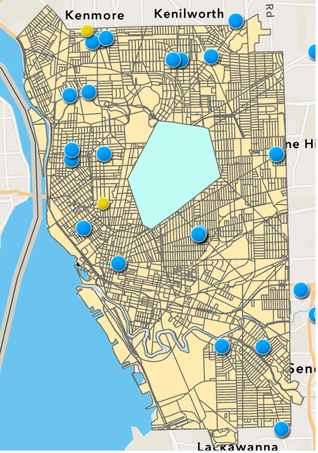
Tops on Jefferson is located within the teal area. The blue and yellow dots are other stores in the city and surrounding suburbs. The teal zone shows the geographic area that’s closer to the Tops on Jefferson than any other major grocery store either within the city of Buffalo or in the suburbs. This geographic area represents 21,914 people. This means that for nearly 22,000 people—just under 8% of the entire City of Buffalo population and over 19% of the population of Buffalo’s East Side—Tops on Jefferson was their nearest major grocery store.
[i]U.S. Census Bureau, 2020 Decennial Census.
This analysis and summary was completed by Anna Blatto, a Research Associate at Partnership for the Public Good.
Special thanks to Dr. Russell Weaver for recommendations on analysis tools and Sydney Deck for additional GIS consultation.